August 5, 2019 | From City of New Orleans
MAYOR CANTRELL, PUBLIC SAFETY OFFICIALS UNVEIL FLOOD WARNING SYSTEM
NEW ORLEANS – Mayor LaToya Cantrell and public safety officials today announced the near completion of a new flood warning system and highlighted other investments made in flood preparedness in the two years since the Aug. 5, 2017, rain event that caused widespread flooding across the city.
“Two years ago a perfect storm of infrastructure failures and torrential rains exposed stark flaws in our drainage system and our flood preparedness,” said Mayor Cantrell. “Since that time, we have worked relentlessly to address our critical needs, to invest in our infrastructure, and to make strategic, meaningful improvements. This new flood warning system is a strong next step, enabling us to detect and monitor rising water in high-risk areas, and to alert drivers to danger. This system replaces the temporary deployment of barricades, freeing up our first responders during a rain event and helping us all to stay safe.”
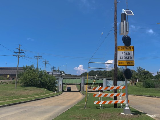
City Installs Flood Warning System
Sensors, weather stations and roadway warning signs have been installed at 12 underpass locations prone to flooding during heavy rain due to their low elevation. Flood sensors will detect when water rises in the low-lying section of the road and will trigger beacons on each side of the underpass to flash, which indicates to drivers that the road is closed due to high water.
Locations include:
- Carrollton Avenue under I-10
- City Park Avenue under I-10
- Canal Boulevard under railroad bridge near Homedale Street
- Downman Road under railroad bridge near Hayne Boulevard
- Franklin Avenue under I-10
- Gentilly Boulevard under I-610
- Gentilly Boulevard under railroad bridge near Peoples Avenue
- Marconi Drive under I-610
- Broad Street under railroad bridge near Florida Avenue
- Paris Avenue under railroad bridge near I-610
- Press Drive under railroad bridge near Leon C. Simon Drive
- Bernard Avenue under railroad bridge near Florida Avenue
Because these locations dip under bridges, they are prone to frequent and flash flooding during heavy rain as water from surrounding streets rushes to the lowest point. The drop in the roadway also makes it difficult for drivers to register the depth of the water when flooded. Consequently, these underpasses have been frequent sites of stalled vehicles and water rescues during storms. In 2018, public safety agencies implemented "Operation Underpass,” a joint effort of the New Orleans Police Department (NOPD) and New Orleans Fire Department to quickly erect barricades blocking motorists from driving into flooded underpasses. The new flood warning system will replace Operation Underpass and will allow those agencies to redeploy personnel to other priority assignments.
“I’d like to remind motorists to never drive through flooded roads,” said NOPD Superintendent Shaun Ferguson. “Doing so can be life threatening and can cause significant damage to vehicles, homes, and businesses. With these flood warning signs at underpasses, the message is clear: if the lights are flashing, the road is closed.”
Beyond warning motorists to turn around, the flood warning system will also provide an additional layer of critical, real-time information to the New Orleans Office of Homeland Security and Emergency Preparedness (NOHSEP), the Sewerage and Water Board of New Orleans, and the National Weather Service during storms. Each installation includes a weather station that measures the real-time rate of rainfall, rainfall total, temperature, and wind speed at the underpass location. There is also a public safety camera connected to the City’s Real-Time Crime Center at nearly all sites.
“Impacts from storms can be highly localized,” said NOHSEP Director Collin Arnold. “Having twelve calibrated weather stations spread throughout the city will give our emergency managers and our drainage partners significantly more situational awareness to make critical and timely decisions during storms.”
Road closure data from the flood warning system will also eventually be displayed publicly on the City’s real-time road hazard website, streetwise.nola.gov.
High Sierra Electronics, a company specializing in environmental monitoring systems, installed the flood warning system, which was procured and project managed by NOHSEP. The cost of the system was approximately $650,000 and was paid for by funds made available in response to the Aug. 5, 2017, flood event. The system is scalable, so as funds become available, additional locations of frequent street flooding will be considered for installation.
Residents Encouraged to Get Ready for Rain
The City of New Orleans is encouraging residents to be ready for rain, which continues to be one of the primary hazards faced in Southeast Louisiana. New Orleans is one of the rainiest cities in the country, with an average of 62 inches of rain each year; and in July 2019 alone, the National Weather Service’s Advanced Hydrological Prediction Service indicated that parts of New Orleans saw between 15 to 20 inches of rain. Excess rainwater that cannot be absorbed must be pumped out, so when heavy rain outpaces the ground's ability to absorb water and the drainage system's capacity, minor and even major flooding can happen.
The City and its partners are investing billions to reduce flooding and improve resilience, including $300 million toward hazard mitigation and resilience projects, $2.4 billion to restore damaged infrastructure, and $5 million for residential green infrastructure, alongside the completion of the $14 billion Hurricane and Storm Damage Risk Reduction System and SELA drainage projects.
However, there are steps residents can take as well to insure property and reduce risk. The City encourages residents to visit ready.nola.gov/rain to learn more about what they can do to reduce their flood risk and to consider the following tips:
Search your address to get a flood risk analysis
The custom-built Ready for Rain property search tool pulls together data from the Flood Insurance Rate Map, LIDAR ground elevation, and the City’s building code to provide an easy-to-understand glimpse of flood risk in New Orleans.
Whether you’re a renter or homeowner, get flood insurance to protect your property
New flood maps were adopted in 2016, making flood insurance even more affordable for many New Orleanians, with the average annual flood insurance premium at $650. Recent floods across the country continue to show that flood insurance provides more recovery dollars than post-disaster assistance programs. In fact, in the past 20 years, New Orleans property owners received seven times more from flood insurance payouts than from post-disaster FEMA funds.
Consider projects to reduce flooding in your yard, including green infrastructure From cleaning gutters, downspouts and in front of catch basins to elevating utilities and structures, there are things you can do to reduce your flood risk. Simple projects like installing a rain garden or rain barrel can also help absorb or hold rainwater, keeping it off the street and away from your structure. Many local community organizations and grant programs are available to assist residents with green infrastructure and mitigation projects.
Track rain and flooding in your community
Get involved in citizen science by tracking rain and flood data on the ISeeChange app. You can also request a free scientific rain gauge provided through a partnership with ISeeChange and NOLA Ready.
Organize a training for your community organization or house of worship
NOLA Ready staff is available to talk to your community organization about flood preparedness and a range of other emergency preparedness topics.
# # #