New Orleans was designated a "silver" level" bicycle friendly community in Fall 2014. For more information, please visit the League of American Bicyclists' website. or to review the report card, click here.
The City of New Orleans Department of Public Works, in concert with the Louisiana Department of Transportation and Development, and the Regional Planning Commission, is implementing the New Century New Orleans Master Plan, Transportation Plan commonly referred to as the Master Plan. The City of New Orleans is coterminous with Orleans Parish. The bikeway network in Orleans Parish currently boasts more than 100 miles of on- and off-street bikeways.
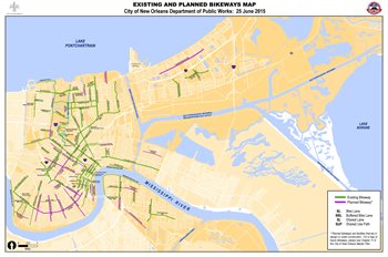
Download a PDF of the City of New Orleans Bicycle Network map here.
Bicycling is an important element of the New Orleans transportation network. According to the American Community Survey, New Orleans has the 10th highest percentage of people who cycle to work each day. The bicycle network has earned Bronze recognition from the League of American Bicyclists for implementing a bicycle friendly community program.
For guidance on how to safely use the bicycle network visit the Bike Easy Map and Guide to Safe Cycling.
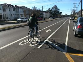
Bike Lane
A portion of the roadway that has been designated for preferential or exclusive use by bicyclists with pavement markings and possibly, signs.(1)
A Bike Lane is intended for one-way travel in the same direction as the adjacent travel lane. Bike Lanes are not intended to accommodate all bicycle use on a roadway; bicyclists may leave a bike lane to pass other bicyclists, make left turns or right turns, avoid debris or other objects, or pass buses or other vehicles momentarily stopped in the bike lane. A Bike Lane typically requires 5 to 6 feet of dedicated roadway.
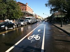
Bike Lanes are typically applied on major streets such as Decatur Street.
Shared Lane
A lane of a traveled roadway that is open to both bicycle and motor vehicle travel. Shared-lane markings typically include pavement marking symbols that indicate an appropriate positioning in a shared lane.(1)
Shared Lanes are typically applied in situations where it is desirable to provide a higher level of guidance to bicyclists and motorists. In some cases, Shared Lanes may be used where insufficient space is available for a designated Bike Lane. A Shared Lane typically requires 10-14 feet of roadway space. The position of the shared line markings indicate the preferred location bicyclists should be riding in the lane.
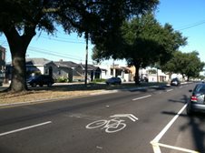
Shared Lanes are typically applied on streets like Orleans Avenue where it is desirable to provide a higher level of guidance to bicyclists and motorists.
Shared Use Path
A bikeway physically separated from motor vehicle traffic by an open space or barrier. Shared use paths may be used by pedestrians, skaters, wheelchair users, joggers, and other non-motorized vehicle users.(1)
Only under limited circumstances should Shared Use Paths be installed on roadway medians or neutral grounds. Two-direction Shared Use Paths are typically 10 – 14 feet wide.
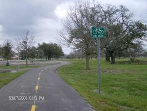
City Park Perimeter Trail Loop is an example of a Shared Use Path through a park
Buffered Bike Lane
Conventional bicycle lanes paired with a designated buffer space separating the bicycle lane from the adjacent motor vehicle lane and/or parking lane. (2)
The buffer generally consists of white pavement stripes. Buffered Bike Lanes are appropriate where adequate space is available. Buffered Bike Lanes can provide bicyclists more travel comfort on streets with high travel speeds, high travel volumes, and/or high amounts of truck traffic.
A Buffered Bike Lane can provide additional comfort and space for bicyclists on major streets.
Protected Bike Lane
An exclusive bike facility that combines the user experience of a separated path with the on-street infrastructure of a conventional bike lane. A Protected Bike Lane is physically separated from motor vehicle traffic and distinct from the sidewalk. Protected Bike Lanes may be one-way or two-way and can be separated from the travel lane in a variety of ways including flexible delineators, raised medians, on-street parking, or bollards.(2)
A Protected Bike Lane can improve perceived comfort and safety of bicyclists. It requires more space than a Bike Lane or Buffered Bike Lane and typically functions best on streets with few conflicts such as driveways or cross-streets.
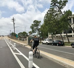
A Protected Bike Lane like this one on the Broad St. Overpass, are preferred by some cyclists.
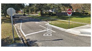
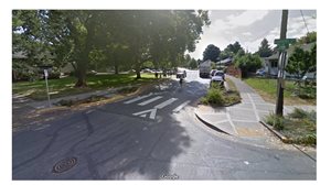
Bicycle Boulevard
Bicycle Boulevards are streets that are designed to prioritize bicycle travel by reducing motorized traffic speeds and volumes. Bicycle Boulevards are useful for making connections through neighborhoods and other low-speed, low-traffic areas where a dedicated bikeway (e.g., a bike lane or trail) is not physically feasible.
Compared to other design treatments, Bicycle Boulevards require the least amount of roadway space reallocation. Bicycle Boulevards can be optimized for bicycling with speed management traffic calming features which may include speed humps, neighborhood traffic circles, curb extensions, and chicanes. They can also be designed to limit traffic volumes and may include traffic diversion features to discourage and reduce through traffic. Bicycle Boulevards typically include pavement markings and signs that communicate a shared environment. Enhanced treatments may be required at intersections with major streets to facilitate low-stress crossings, such as signals and median refuges.
Bike Rack
A stationary fixture to which a bicycle can be securely attached.(2)
Bike Racks come in a variety of shapes, sizes and materials. Bike Racks typically are installed along sidewalks so that they provide convenient access for bicyclists but also do not obstruct the pedestrian access route. A Bike Corral is a group of several bicycle racks that are installed on the street.
Bike Racks that are installed on public sidewalks and streets require approval by the DPW. Click here for an application to install a bike rack corral on the public right of way. DPW staff can provide guidance on appropriate rack types, materials, and layout.
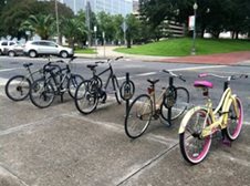
Bike Racks such as these on Perdido Street provide designated parking for bicycles.
(1) American Association of State Highway And Transportation Officials (AASHTO) Guide for the Development of Bicycle Facilities,4th Ed., 2012.
(2) National Association of City Transportation Officials (NACTO) Urban Bikeway Design Guide, 2nd Ed.
Moving New Orleans Bikes
Moving New Orleans Bikes is an effort to improve safety, access, and connectivity for people riding bicycles. Along with transit, walking, and driving, bicycling is an important transportation option that provides numerous benefits to individuals, families, and our city - even for people who never ride! A better bicycle network will provide job access, health benefits, reduce demand for parking, and improve the quality of life.
Learn more here.