The New Orleans City Planning Commission was established 100 years ago in the City Charter. The Commission has a number of very specific duties, including the adoption of a Master Plan, Comprehensive Zoning Ordinance, Capital Improvement Plan, and the official Map of the City - among other responsibilities. These documents reflect the physical growth of the New Orleans as well as an evolving vision of what the city could be. The pages linked below contain digital copies of historical maps and plans kept in the CPC archive that could be of interest to the public. They will continue to be updated as additional records from the archive are digitized.
Former Comprehensive Zoning Ordinances
Section 5-402(d) of the City Charter tasks the CPC with preparing a zoning ordinance and revision and amendments thereof for the purpose of promoting the public health, safety, aesthetics, and general welfare of the City, and implementing the Master Plan. The first Comprehensive Zoning Ordinance for the City of New Orleans was adopted in 1929 and the City has since fully revised its CZO three times (1953, 1970, and 2015). The documents linked below include the text and associated maps from the former CZOs. The text of the current CZO can be viewed at czo.nola.gov and the current zoning map at property.nola.gov.
Land Use Maps
During its many CZO and Master Plan processes over the last century, the CPC developed land use maps to help document existing conditions and inform policy decisions for CZO revisions. The documents linked below include several sets of citywide land use maps that CPC staff continues to use today to document individual property’s land use over time.
Subdivision Regulations & Index Cards
Section 5-402.2 of the City Charter requires the CPC to prepare, adopt, amend and modify regulations governing the subdivision of land, including platting and replatting; which regulations shall provide for the proper arrangement of streets and public utilities; open spaces for light, air and recreational areas; space for vehicular parking; the sizes and shapes of lots in order to avoid congestions of population and to provide for the amenities of human habitation; and the manner and extent to which streets shall be paved and public utilities installed in such subdivisions, consistent with the provisions of this Charter.
The documents in the tables below include past versions of the Subdivision Regulations and records of subdivision applications dating from 1950 to 2000. Each index card is sorted by applicant name and all PDFs are in a searchable format.
| TIMELINE OF SUBDIVISION REGULATIONS STUDY AND AMENDMENTS (1949-1986) |
PDF |
| 1950 SUBDIVISION REGULATIONS 3RD EDITION (1962) |
PDF
 |
| 1986 SUBDIVISION REGULATIONS |
PDF
|
| SUBDVISION INDEX CARDS |
| ACR - BAGERT |
PDF (93MB) |
| BAGNERIS - BONURA |
PDF (93MB) |
| BOONE - CANAL |
PDF (93MB) |
| CANARLES - COLTRARO |
PDF (90MB) |
| COMISKEY - DEFRAITES |
PDF (105MB) |
| DEFRANCO - EARNEST |
PDF (104MB) |
| EAST LAKE - FOURSITE |
PDF (107MB) |
| FORSTALL - GRAZYCH |
PDF (125MB) |
| GREATER - HIBERNIA |
PDF (108MB) |
| HICKEY - JEANSONNE |
PDF (108MB) |
| JEFF DAVIS - LAKE CATHERINE |
PDF (103MB) |
| LAKE FOREST - LA KRATT |
PDF (110MB) |
| NEW ORLEANS - PARK PLACE |
PDF (104MB) |
| PARK REALTY - PRICE |
PDF (103MB) |
| PRIDE - ROMANO |
PDF (105MB) |
| ROMAREBO - SCIAMBRA |
PDF (116MB) |
| SCIFO - SPRUCE |
PDF (106MB) |
| SPRUIELL - TRINH |
PDF (106MB) |
| TROMBINO - WARREN |
PDF (106MB) |
| WASHINGTON - ZWART |
PDF (115MB) |
Hurricane Katrina Recovery Plans
In the aftermath of Hurricane Katrina, numerous plans were developed to strategically guide the city's recovery. The documents on this page include many citywide and neighborhood-specific plans created during this time.
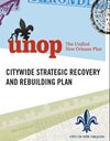
UNIFIED NEW ORLEANS PLAN (UNOP)
In August of 2006, the Greater New Orleans Foundation assembled the funding to support a broad-based citizen planning process, the Unified New Orleans Plan (UNOP). This cumulative and culminating plan would provide a citywide recovery plan that would serve as the “official” recovery plan for the City of New Orleans. Linked in the table below is the Citywide Strategic Recovery and Rebuilding Plan and individual plans for each Planning District in the city.
| CITYWIDE STRATEGIC RECOVERY AND REBUILDING PLAN |
Plan
 |
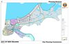
| UNOP DISTRICT PLANS |
Map
 |
NEIGHBORHOOD REBUILDING PLANS
Approximately 100 days after Hurricane Katrina struck, Motion M-05-592 was introduced and unanimously passed by the City Council. The Motion ensured that community-based neighborhood-by-neighborhood planning for flooded areas of the City would be central to decisions associated with the recovery of the most devastated areas of New Orleans. The Council was adamant that the families most impacted by the storm would play a central role in defining the future of their communities. In late March of 2006, the City of New Orleans contracted with a team of consultants to assist those neighborhoods flooded by Hurricane Katrina to develop neighborhood level revitalization plans. Specifically, the consultants were engaged to assist residents to produce neighborhood-by-neighborhood recovery plans for up to forty-nine (49) City Planning Commission designated neighborhoods that sustained flooding in excess of two feet of water. The summary and neighborhood plans are linked in the table below.
| SUMMARY |
PDF
 |
| NEIGHBORHOOD PLANS |
Map
 |
Various Past Maps & Plans
The City Planning Commission conducts or participates in many citywide and area-specific planning initiatives. These studies are typically called by the Commission, Mayor, or the City Council. The documents linked below are some of the plans that have been recently discovered in the CPC archive and scanned due to their potential interest to the public. This page will be updated as studies are re-discovered and digitized.
| 1920 MAP OF THE VIEUX CARRE WITH SUBURBS |
MAP
 |
| 1929 PLAN FOR A NEW CIVIC CENTER |
PDF
 |
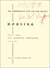
| 1954 COMPREHENSIVE PLAN FOR NEW ORLEANS CHAPTER 10: HOUSING |
REPORT
 |
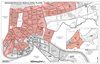
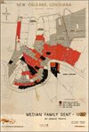
MAPS
 |
| 1957 PROSPECTUS FOR REVITALIZING NEW ORLEANS CENTRAL BUSINESS DISTRICT |
REPORT
 |
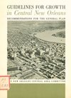
| 1965 GUIDELINES FOR GROWTH IN CENTRAL NEW ORLEANS RECOMMENDATIONS FOR THE GENERAL PLAN |
REPORT
 |
| 1970 COMMUNITY RENEWAL PROGRAM |
REPORT

|
| 1970 ECONOMIC FACTORS OF THE COMMUNITY RENEWAL PROGRAM |
REPORT

|
| 1970 CANAL STREET IMPROVEMENT PROJECT |
REPORT
 |
| 1975 CENTRAL AREA NEW ORLEANS GROWTH MANAGEMENT PROGRAM TECHNICAL REPORT |
REPORT
 |
| 1975 The Orlandia Plan |
REPORT

|
| 1976 CBD IMPLEMENTATION STRATEGY, PROGRAM AND ZONING PLAN |
Report
 |
| 1978 New Orleans Housing Plan: Needs and Strategies |
REPORT

|
| 1978 New Orleans Land Use Plan: Present and Future |
REPORT

|
| 1980 LAND USE COMPREHENSIVE MANAGEMENT PLAN |
REPORT
|
| 1983 Algiers Study |
REPORT
|
| 1986 CENTRAL AREA NEW ORLEANS GROWTH MANAGEMENT PLAN UPDATE |
Report
 |
| 1997 Lower Garden District Strategic Renaissance Plan |
REPORT
|
| 2004 New Orleans East Renaissance Plan |
REPORT
|